.png) 5 hours ago
9
5 hours ago
9
Heritage campaigners are bidding for listing status for two concrete pillars hailed as “modest obelisks of modernity in the countryside”.
These functional 120cm (4ft) stone or concrete “trig points” formed part of a 6,500-strong network of surveying posts that were vital for the development of modern mapping.
They have since been rendered obsolete by GPS and drones but are still beacons for walkers and the focal points of countless hilltop group photos and selfies. They have even sparked a niche hobby of trig-bagging for those intent on visiting all of them.
Now the Twentieth Century Society (C20), which campaigns to preserve modern architecture and design, has applied for listing status for the first and last of these posts to be used.
These two trig points bookend an ambitious mapping and reference project – the Retriangulation of Great Britain.
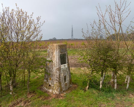
The first was built 90 years ago this week in Cold Ashby, Northamptonshire. For mapping aficionados and trig baggers, it is at grid reference: SP 64422 76588. The final observation was taken on 4 June 1962 at Thorny Gale in Cumbria (NY 82516 13912). C20 has submitted an application to Historic England for both to be protected under Grade II-listed status.
Trig points were designed by Brig Martin Hotine – a former Royal Engineers officer and veteran of the first world war, who led the retriangulation project for the Ordnance Survey (OS).
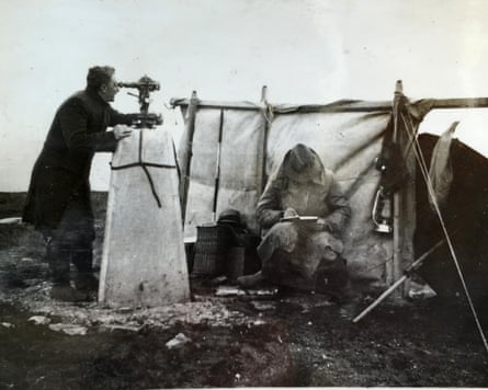
Sometimes referred to as Hotine Pillars, these tapered posts were topped with a brass plate for fixing theodolites – precision instruments used by surveyors to accurately map the British Isles. They came with brass loops for tying down theodolites in high winds.
On a clear day it was once possible to see at least two other trig points from any other – allowing Hotine’s team to map the whole country using a network of triangles.
Hundreds have been lost to building development, farming and coastal erosion, and none have been listed. In the 1990s, OS suggested removing unwanted pillars to save maintenance costs.
But after a backlash from campaigners, including the Ramblers, OS withdrew the demolition plan. Instead, responsibility for maintenance was transferred to local groups. Thousands remain as landmarks on high ground – the highest is on the summit of Scotland’s Ben Nevis.
C20’s application acknowledges that trig pillars are now “more or less obsolete”, but “they still act as a beacon for ramblers and are a symbol of the British countryside.”
It argues their cultural importance goes beyond their former functional use. The American writer Bill Bryson listed trig points as one of his “favourite British items” in his book, The Road to Little Dribbling.
They also inspired the name and logo of the former indie record label the Angular Recording Corporation, which launched several bands including Bloc Party and the Long Blondes.
In a conclusion to the application, C20 said: “These modern obelisks to modernity in the countryside are remnants from a nationwide surveying project of unprecedented scale. We urge Historic England to award this gem its deserved place on the national heritage list for England.”
Catherine Croft, director of the C20, said: “Long before GPS, satellite technology and navigational apps on our mobile phones, trig points were the humble concrete pillars that mapped a nation.
“As the landmark Retriangulation of Great Britain celebrates its 90th anniversary, we spied an opportunity to put a figurative pin-in-the-map and have submitted the two most historically important trig points – the first and last examples – to be nationally listed.
“Nothing beats the modest triumph of standing on top of a trig point in a brisk wind and we hope these two modern obelisks of concrete in the countryside will soon be recognised by the Department for Culture, Media and Sport.”